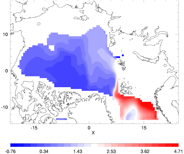
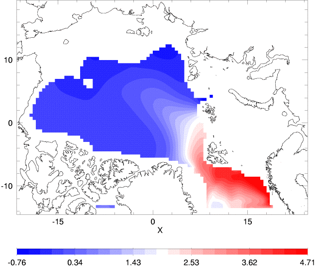
Temperature, salinity and circulation are compared at depths associated with the Atlantic Layer.
The Arctic Ocean Model Intercomparison Project (AOMIP) is an international effort comparing different numerical models of the Arctic Ocean under realistic forcing. At present there are fifteen modeling groups participating in AOMIP:
| Code | Institution | Country |
| AWI | Alfred Wegener Institute | Germany |
| GSFC | Goddard Space Flight Center | USA |
| ICMMG | Institute of Computational Math and Math Geophysics | Russia |
| IOS | Institute of Ocean Sciences | Canada |
| LANL | Los Alamos National Laboratory | USA |
| LU | Laval University | Canada |
| NERSC | Nansen Environmental and Remote Sensing Center | Norway |
| NPS | Naval Postgraduate School | USA |
| NYU | New York University | USA |
| POL | Proudman Oceanographic Laboratory | UK |
| RAS | Russian Academy of Science | Russia |
| RCO | Rossby Center, Swedish Meteorol. & Hydrol. Institute | Sweden |
| UAF | University of Alaska at Fairbanks | USA |
| UCL | Universite Catholique de Louvain | Belgium |
| UW | University of Washington | USA |
Specifications for the different models are given in tables (click to view).Dysfonction érectile.
Goals are to examine how the different models simulate Arctic ice/ocean variability on seasonal through multidecadal timescales. Understanding how different physical assumptions and numerical methods affect model results helps us understand the roles of actual processes in the Arctic and helps build a confident basis for modeling the Arctic. Comparing model results with observations, AOMIP seeks to identify and to correct systematic errors among present models, suggesting improvements for Arctic components of global models. Slides from an overview talk give some highlights about AOMIP.
AOMIP proceeds through three phases. A first phase could be called "uncoordinated". Although modest efforts were made to use common forcing data, etc., model setups differed in many regards. In a second ("coordinated") phase many aspects of model setup, initialization and forcing have been done in a common way based upon a 55-year integration period from 1948 through 2003. A 3rd coordinated phase will extend integrations oveer 100 years. Protocols for coordinated phases, as well as other project information, are given on the AOMIP home site.
Some results from the first (uncoordinated) phase can be viewed by clicking the following thumbnail figures.
|
Temperature, salinity and circulation are compared at depths associated with the Atlantic Layer. |
|
An experiment using one of the AOMIP models helps explain some of the differences among model outputs. | |
|
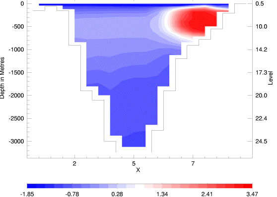
Temperature, salinity and flow are compared on a vertical section across Fram Strait. | |||
Sponsored by the National Science Foundation through the University of Alaska and the Woods Hole Oceanographic Institution, PlanetWater helps support the role of IOS in AOMIP. Materials presented through this web page reflect IOS/PlanetWater participation.
to PlanetWater |
 |
or | more research |
 |